
Part 1
First, it was all about fractions. These activity sheets are from Math to the Max 3.
 We have continued using pattern blocks to cover figures on the page and then trace what we’ve done. Students are being asked to think of covering a figure with blocks that represent a specific fraction but this doesn’t mean you can tell from the fraction how many of each block you will need. It is necessary to visualize the figure in thirds to complete this task. Look closely.
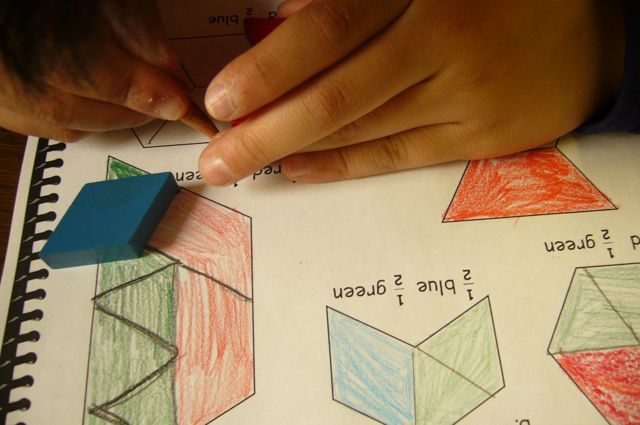 On this page (pictured right) students were asked to visualize the shape split in half. If a figure is half blue and half green, it might be one blue block and two green blocks, because two green blocks cover one blue block. When adding a red block, you then must add three green. So a figure can be covered in two red blocks and six green blocks and be 1/2 red and 1/2 green. Some of these took multiple attempts before they were figured out.
Part 2
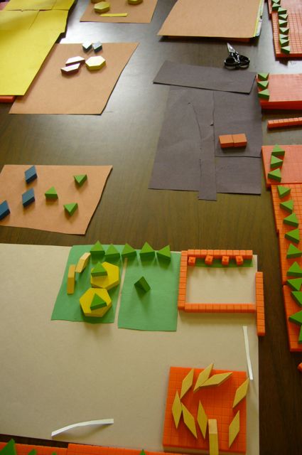
Then, in the afternoon, we moved on to making a maps. The task? Create a map of the school yard from a “bird’s eye view” perspective. The criteria?
- work cooperatively within a small group
- use any flat objects you can find in the classroom to represent buildings, places, objects (Students used paper, base ten materials, rulers, pattern blocks, lego, etc)
- no pencils or crayons allowed
- be prepared to explain any parts of your “map” at any time
- anything you take out, must be put away at clean up time
- have fun!
The results were fascinating!
 These students were able to “visualize” certain areas of the school grounds very easily. In the foreground of this photo you can see their earthquake shed, the garden, the garden bench.
The only problem? They couldn’t orient themselves clearly. Their garden area is actually where the brick building should be and on the other side.
There was lots of talking, lots of discussion, lots of flexibility around new ideas within this group but nobody could get a vision happening that everyone could understand. This task was harder than it first seemed!
 This group worked very well together. If you listened to them, they kept cheering each other on. “We have to really work together here!” “Good idea!” “Why don’t we try . . ?” In this picture you can see that the pieces of paper represent both school buildings and the large grey paper represents the gravel field complete with goal posts.
 Here is the same group again from a different perspective. These students had thought out breaks in the fence (for entrances, parking lot, etc.) They had included the playground, the basketball court, the concrete soccer area, the stairs to sit on and watch, the spinners, etc. etc.
Anytime somebody said, “What about. . .?” everyone stopped and figured out a way to adjust the map. This was the beauty of building this rather than trying to draw and continually erase.
This group even cut out green circles of paper to represent trees as they would look circular from above. Clever
 I love this version of a parking lot spaced out using lego pieces. The problem for this group is that it was too big compared to the scale of their buildings, etc. How could they take this idea and modify it? Unfortunately we ran out of time before they could think this through. The little green triangles represent the grass on the sidewalk surrounding the school.
Why did we do this? Well, for many reasons. We are beginning a mapping unit to look at Canada in North America. I wanted students to understand that the drawing on a paper of a map is a representation of the world we actually live in. This is very hard for some students to grasp because of course we don’t inhabit a flat two dimensional world. I thought if we tried to represent our “little world” of Seymour School on a map (built, not drawn and from a bird’s eye view perspective) it might open up our thinking when we try to visualize how a map represents places we live. If nothing else, it was an awesome hands on, creative, student centred activity. Lots of thinking. Lots of discussion. A little bit of arguing (of course 🙂 ) Some new perspectives. Well done Division 5!

This is a fantastic idea and a great way to get students to think of mapping by trying to create something familiar in a two dimensional manner and then bring it into mapping!
You are an awesome teacher!!! I like how each group thought it through and added complexity, and took it to their level.